Geology 105 Solved
Question 1
Download The Solution Here
$75.00Add to cart
What river system feature is seen in this picture?
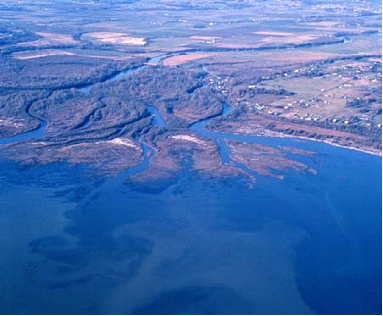
| V-shaped valley | ||
| Tributary | ||
| Alluvial fan | ||
| Delta |
Question 2
This Google Earth image of Mount Hood in Oregon displays which common type of drainage pattern?
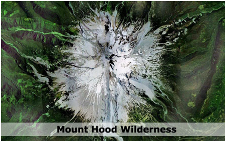
| parallel | ||
| trellis | ||
| radial | ||
| dendritic |
Question 3
Water can enter the groundwater system
| a. | through cracks and fractures in very hard rocks, like igneous and metamorphic rocks. | |
| b. | through the pore spaces found in sedimentary rock. | |
| c. | through the process known as infiltration. | |
| d. | only after it rains; otherwise there is no groundwater to be found no matter how deep you dig. | |
| e. | Both a & b are correct. | |
| f. | a, b & c are all correct. | |
| g. | all of the above are correct. |
Question 4
What river system feature is seen in this picture?
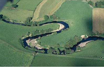
| Oxbow lake | ||
| V-shaped valley | ||
| Meander | ||
| Rill |
Question 5
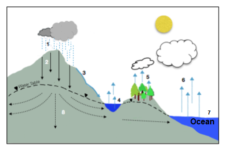
Identify the numbered features in the diagram below.
|
|
|||
| 1 | Precipitation | ||
| 2 Infiltration |
| 3 | Runoff |
| 4 | Temporary Base Level |
| 5 | Transpiration |
| 6 Evaporation |
| 7 Ultimate Base Level |
|
|
Question 6
I have noticed that poison ivy seems to be more abundant, showing up earlier in the spring and growing more vigorously. Might I be able to contribute this to increased levels of CO2 in the atmosphere?
True
False
Question 7
The Earth recently past a milestone in CO2 concentration in the atmosphere. This milestone was
| 100 PPM | ||
| 350 PPM | ||
| 1000 PPM | ||
| 400 PPM |
Question 8
Tributary glaciers, that once fed larger valley glaciers, leave this characteristic valley behind after the ice has melted:
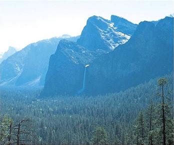
| V-shaped valley | ||
| glacial till valley | ||
| hanging valley | ||
| valley with a pretty waterfall |
Question 9
Eroded rock material deposited in a large mound at the terminus of a glacier as seen in this picture is called
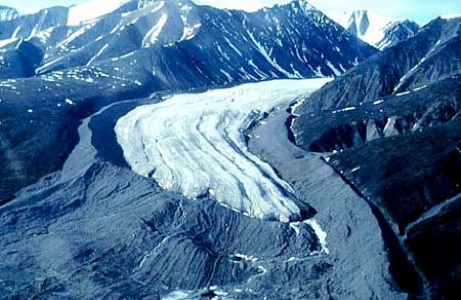
| a. | a moraine | |
| b. | glacial till | |
| c. | a cirque | |
| d. | a point bar | |
| e. | Both a & b are correct. | |
| f. | Both c & d are correct. |
Question 10
Overuse of groundwater may
| lower the water table. | ||
| cause wells to fill with saltwater (if located near the ocean). | ||
| cause the land surface to sink. | ||
| all of the above. |
Question 11
Which of the following analyses indicate that humans are the cause of increasing CO2 in our atmosphere? Select only those answers that apply. Selecting incorrectly will result in points subtracted.
| Declining levels of O2 found in the atmosphere | ||
| Increasing alignment of the Milankovitch cycles | ||
| Ratios of Carbon isotopes C12, C13, C14 found in the atmosphere | ||
| increasing solar output | ||
| changes in El Nino and La Nina cycles | ||
| recent increases in large volcanic eruptions like Mount Saint Helens and Mt. Pinatubo |
Question 12
A glacially eroded valley has a characteristic shape, it
|
|||
|
|||
|
|||
|
Question 13
What type of land feature is seen in this photo?
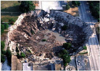
| oxbow lake | ||
| talus cone | ||
| sinkhole | ||
| cone of depression |
Question 14
Which of the following statements is the most accurate summary of stream flow characteristics?
| The largest particles are found in the low gradient part of the stream channel and the greatest velocities are recorded in the high gradient part of the channel. | ||
| The largest particles are found in the high gradient part of the stream channel and the greatest velocities are recorded in the high gradient part of the channel. | ||
| The largest particles are found in the high gradient part of the stream channel and the greatest velocities are recorded in the low gradient part of the channel. | ||
| The largest particles are found in the low gradient part of the stream channel and the greatest velocities are recorded in the low gradient part of the channel. |
Question 15
The elongate scratches were formed when a continental glacier scoured the bedrock. They are called
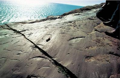
| glacial till | ||
| plucking | ||
| cirques | ||
| glacial striations |
2 points
Question 16
Examine the following diagram:
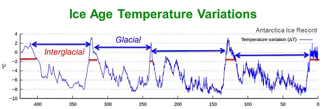
The last ice age can be divided into ___________________ and __________________.
| long, cold glacials; short, warm interglacials | ||
| short, warm glacials; cold interglacials | ||
| long, warm glacials; short cold interglacials | ||
| short, cold glacials, long, warm interglacials |
Question 17
Short term climate cycles are related to fluctuations in Earth’s orbit and changes in the tilt of Earth’s axis.
True
False
Question 18
This pyramid shaped glacial landform is called a(an)
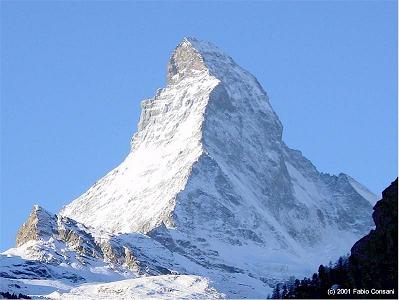
| horn | ||
| cirque | ||
| arete | ||
| moraine |
Question 19
The steep sided, half-bowl shaped valley that forms at the head of a valley glacier is called a(n)
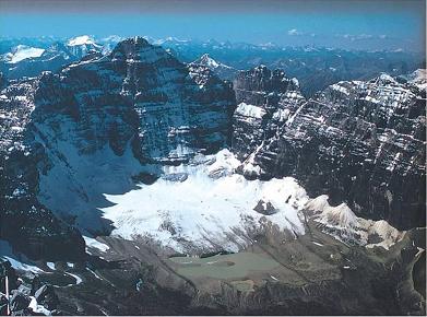
| horn | ||
| tarn lake | ||
| arete | ||
| cirque |
Question 20
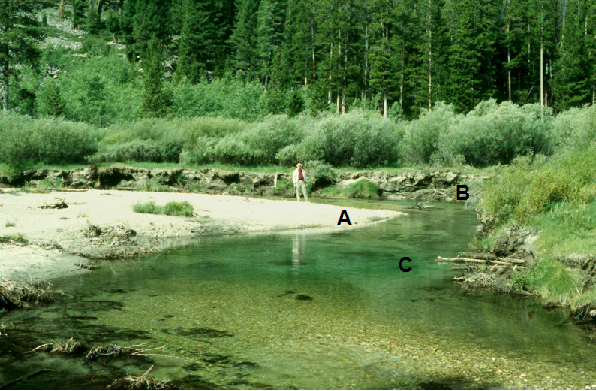
Match the features and characteristics with those identified on the diagram below.
|
|
||
| cut bank B | ||
| Deposition A |
| point bar A
Erosion B |
| river channel C |
Question 21
Most of the spectacular cave systems (ex: Luray Caverns, Skyline Caverns) are formed by
| the dissolving of evaporite deposits, such as rock salt. | ||
| sculpting cavemen | ||
| sinkholes | ||
| the dissolutioning of limestone by weakly acidic groundwater. |
rivers
Question 22
Most of Earth s fresh water exists in
| glacial ice | ||
| groundwater | ||
| lakes | ||
| rivers |
Question 23
Causes of glaciation can be linked to
| variations in Earth’s orbit | ||
| continental arrangements due to plate movement | ||
| changes in ocean circulation patterns | ||
| all of the above |
Question 24
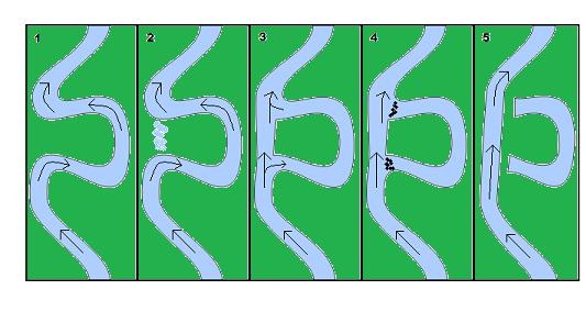
When meandering channel curves join in a downslope cut-through, this creates a cut-off meander followed by a(n) ______________________ as seen in the picture below.
| C – shaped curve | ||
| Phantom curve | ||
| Oxbow Lake |
Question 25
The boundary between the saturated zone and the unsaturated zone is called the _____.
| Water table | ||
| Permeability | ||
| Hydrologic Cycle | ||
| Aquifer |
Question 26
The percentage of the Earth’s surface that is covered by water is about:
| 10%. | ||
| 30%. | ||
| 50%. | ||
| 70%. | ||
| 100% |
Question 27
Which gas, that forms a distinct layer in the atmosphere, also protects us from the damaging rays of ultraviolet radiation?
| water vapor | ||
| ozone | ||
| methane | ||
| nitrous oxide | ||
| carbon dioxide |
Question 28
Groundwater moves from an area of higher elevation to an area of lower elevation.
True
False
Question 29
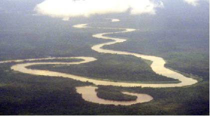
What old age river system feature appears in the bottom center of the photo below?
| base level | ||
| point bar | ||
| oxbow lake | ||
| natural levee |
Question 30
An arete is a
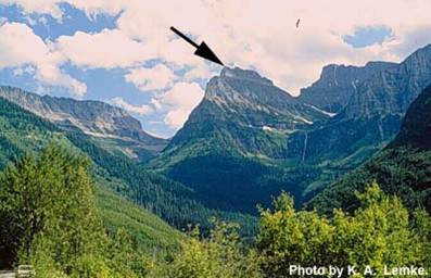
| knifelike ridge between glacial valleys | ||
| deposit of unsorted sand and gravel | ||
| pyramid-shaped peak eroded by continental glaciers | ||
| type of glacier found in mountain valleys |
Question 31
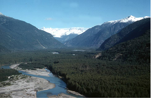
Match the correct answers below.
|
|
||
| The flat area between the hills represents the B | ||
| Sediment gets deposited on the inside of a curve in a D |
|
|
Question 32
Most of Earth’s fresh water exists in
| glacial ice | ||
| groundwater | ||
| lakes | ||
| rivers |
Question 33
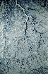
The most common drainage pattern appears below. What type of drainage pattern is it?
| rectangular | ||
| trellis | ||
| dendritic | ||
| radial |
Question 34
The downhill slope of the stream bed is measured in feet/mile or meters/kilometer and referred to as the stream
| discharge | ||
| velocity | ||
| gradient | ||
| profile |
Question 35
Streams or rivers can erode the land surface area down to the elevation found at the mouth of the stream. This elevation is called
| base level. | ||
| erosion level. | ||
| the flood plain. | ||
| the gradient. |
Question 36
Groundwater is mildly acidic due to
| the reaction of rainwater with carbon dioxide in the atmosphere and soil | ||
| the reaction of rainwater with limestone surface rocks. | ||
| percolation through sandstone | ||
| mixing with river water. |
Question 37
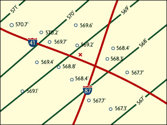
In the following groundwater table map, the small circles represent the elevation of the ground water at various wells. The green lines represent groundwater table contours. In what general direction is the groundwater flowing?
| northeast | ||
| southeast | ||
| southwest | ||
| northwest |


